 Growth & Development Tracker – Chino Valley, AZ
Official Planning & Zoning Tools
 Town Planning Division – Current Planning: Access zoning changes, subdivision proposals, conditional use permits, and site plans.
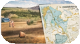
Town GIS Maps & Parcel Data: Explore parcel ownership, zoning, and aerial imagery to track development visually.

2040 General Plan: View the long-term framework for land use, future growth, and community vision.

Infrastructure & Capital Improvement Projects
 Capital Improvement Plan (CIP): See upcoming street, utility, and public facility projects that indicate growth trends.
Highway 89 Projects: Updates on road widening, traffic improvements, and supporting infrastructure.
Zoning & Community Engagement
Zoning Ordinance U pdate: Interactive issues map, public feedback, and proposed ordinance changes.
 Economic Development Tools: Monitor business openings, incentives, and land available for development.
How to Use This Tracker
Visitors can:
- Follow pre-application meetings and project review schedules.
- Check planning commission and town council agendas/minutes for updates.
- Visualize growth with parcel maps, zoning overlays, and aerial imagery.
- Stay engaged with interactive public feedback portals and referenda opportunities.
This tracker provides a centralized resource for residents and stakeholders to monitor growth while preserving Chino Valley’s rural character.